Results for gallery: Water(click on a photo to get larger photo and more details)
 | Big Bay Point - Fall Colors Photo of looking out towards the Government Dock at Big Bay Point in Innisfil, Ontario, Canada. Located on Sideroad 30, near Lakeside Drive. Taken when most of leaves have fallen.
| ||||
 | Big Bay Point - Government Dock - Panorama Photo take at the head of the Big Bay Point Government Dock, in Innisfil, Ontario, Canada. Panorama of skyline shows parts of Barrie and Shanty Bay.
| ||||
| Body Blast in Splash Works at Canadas Wonderland View of Body Blast slide at Canada's Wonderland. The Behemoth roller coaster is in the background.
| |||||
 | Eyjafjallajokull eruption-washed out road at Seljalandsfoss The view from Seljalandsfoss. Road was washed out from the recent Eyjafjallajokull eruption.
| ||||
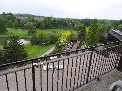
 | Nottawasaga Inn Resort - Room 676 view of patio Room in Nottawasaga Inn Resort and Conference Centre, near Alliston Ontario. View of golf course, conference patio and Nottawasaga River from balcony.
| ||||
 | Oastler Lake at Oastler Lake Provincial Park View of Oastler Lake, taken in the summer of 2014 at Oastler Lake Provincial Park Canada.
| ||||
 | Photo of the boiling water of Litli Geysir Photo of the Litli Gesir bubbling from the heat. It is located at the same site as the Great Geysir.
| ||||
| Ring Necked Duck - Male - at Minesing Swamp Male Ring Necked Duck swimming in the spring run off at Minesing Swamp, also know as the Minesing Wetlands. Taken in early April 2014.
| |||||
 | River crossing along F208 Iceland north to Landmannalaugar Photo of watercrossing along F208 Iceland north towards Landmannalaugar. This river is located near Ofaerufoss in Eldgjá.
| ||||
 | Sign showing history of flow of Markarfljot river in Iceland Sign showing the path of the Markarfljot river, and relted waterfalls, like Seljalandsfoss. Source of the river is the Eyjafjallajokull glacier.
| ||||
 | Sign showing history of washouts from Markarfljot river Sign showing history of washouts from Markarfljot river. Located at Seljalandsfoss. Road was washed out from the recent Eyjafjallajokull eruption.
| ||||
 | Strokkur geyser after the eruption Photo of the Strokkur geyser after it has erupted. It is located at the same site as the Great Geysir.
| ||||
| Strokkur geyser erupting Photo of the Strokkur geyser erupting. It is located at the same site as the Great Geysir.
| |||||
| Strokkur geyser erupting from a distance Photo of the Strokkur geyser erupting. It is located at the same site as the Great Geysir.
| |||||
| Strokkur geyser waiting for the next eruption Photo of the Strokkur geyser after it has erupted, waiting for the next eruption. It is located at the same site as the Great Geysir.
| |||||
 | Trent-Severn Waterway Sign - Lock 42 - Washago Shop Sign leading up to the Lock 42 station of the Trent-Severn Waterway. The sign indicates that this is a national historic site. Another name for this areas is the Washago Shop.
| ||||
 | View of Skaftafellsjökull glacier drainage basin View of Skaftafellsjökull drainage basin from the Sjónarnípa viewpoint on walking trail at Skaftafell National Park. Drainage ends at Atlantic Ocean.
| ||||
| Watson Lake in Algonquin Park View of Watson lake in October 2013. Located off of a service road in the south end of Algonquin Park.
| |||||

