MyWorldOfPhotos.com


Results for gallery: Historical(click on a photo to get larger photo and more details)

Location Filters

Taxonomic Filters

Other Attribute Filters

prev|1|2|3|4|next
1920's Photo of Toronto Union Station1920's Photo of Toronto Union Station
1920's Photo of Toronto Union Station. Located at Fairmont Royal York Hotel in Toronto on Front Street.

Photo Attributes:Toronto, Canada, 2011, Front Street, Yonge Street, Toronto Union Station, Ontario,
In these galleries:Buildings, Historical, Train Stations

Banff Springs Hotel EntranceBanff Springs Hotel Entrance
Entrance of the Fairmont Banff Springs Hotel. Photo was taken in 1999. Located in Alberta Canada.

Photo Attributes:Fairmont Banff Springs, Banff, 1886, Canada, 1999, Fairmont Banff Springs, Alberta,
In these galleries:Historical, Hotels
Photo Specific Links:Fairmont Banff Springs History

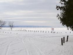
Blue Mountain and Wasaga Beach Winter 2014 ZoomBlue Mountain and Wasaga Beach Winter 2014 Zoom
A winter landscape view of Wasaga Beach, the Blue Mountains and the Collingwood Terminals Limited Grain Elevator. Photo was taken from the beach area 6 location of Wasaga Beach, across a frozen Georgian Bay.

Photo Attributes:Collingwood, Wasaga Beach, 1929, Canada, Simcoe County, 2014, Hurontario Street, Wasaga Beach Area 6, Collingwood Terminals Limited, Wasaga Beach, Georgian Bay, Blue Mountains, Ontario,
In these galleries:Beaches, Harbours, Historical, Landmarks, Landscapes, Mountains, Winter

Brookfield Place RBC Dominion Securities building Brookfield Place RBC Dominion Securities building
Photo of RBC Dominion Securities building, in Brookfield Place. Located in Toronto at Front and Yonge Streets. Also entrance to BCE Place.

Photo Attributes:Toronto, Canada, 2011, Front Street, Yonge Street, Hockey Hall of Fame, Brookfield Place, Ontario,
In these galleries:Architecture, Historical

Cabot Head Light Station - History of the LighthouseCabot Head Light Station - History of the Lighthouse
A sign posted on the original Cabot Head Lighhouse describing the history of the Cabot Head Light Station. Located near Tobermory Ontario.

Photo Attributes:Canada, Bruce County, 2011, Bruce Peninsula National Park, Cabot Head Light Station, Lake Huron, Ontario,
In these galleries:Historical, Information Signs, Lighthouses, Signs

Cabot Head Light Station - LighthouseCabot Head Light Station - Lighthouse
Shows the old and new light stations. The original lighthouse went into operation in 1896. The existing tower was built in 1968.

Photo Attributes:Canada, Bruce County, 2011, Bruce Peninsula National Park, Cabot Head Light Station, Lake Huron, Ontario,
In these galleries:Historical, Lighthouses

Cape Florida Lighthouse on Key Biscayne, land view. Cape Florida Lighthouse on Key Biscayne, land view.
Photo of the Cape Florida Lighthouse, land view. Located in Bill Baggs State Park on Key Biscayne Island.

Photo Attributes:Key Biscayne, 1825, United States, Miami-Dade, 2009, Bill Baggs State Park , Key Biscayne National Park,
In these galleries:Historical, Lighthouses
Photo Specific Links:Cape Florida Lighthouse History

Caste War in Mexico - Sign at Tulum RuinsCaste War in Mexico - Sign at Tulum Ruins
An information sign within the Tulum Ruins in the Mayan Riviera of Mexico. Describes the 1847 uprising by the indigenous people, it was called the Cate War.

Photo Attributes:Mexico, Tulum, 2006, Quintana Roo,
In these galleries:Caribbean, Historical, Information Signs, Mayan Ruins, Signs

Caste War of Yucatan - on sign in Tulum RuinsCaste War of Yucatan - on sign in Tulum Ruins
The Caste War was from 1847 to 1900. This photo taken in the Tulum Ruins of the Maya site. Mayan ruins.

Photo Attributes:Mexico, 2006, Tulum Ruins of the Maya, Yucatan,
In these galleries:Historical, Mayan Ruins, Signs
Photo Specific Links:Caste War of the Yucatan - wikipedia

Chicago Cultural Center - in the eveningChicago Cultural Center - in the evening
Evening photo of the Chicago Cultural Center. Is America's first free municipal cultural center.

Photo Attributes:Chicago, 1893, United States, 2014, E. Washington Street, Chicago Cultural Center, Illinois,
In these galleries:Buildings, Cultural, Historical, The Evening

Climbing the Nohoch Mul Pyramid in Coba Mexico Climbing the Nohoch Mul Pyramid in Coba Mexico
Steepness of the climb can be seen from this angle.

Photo Attributes:Mexico, 2006, Mayan Ruins of Coba, Quintana Roo,
In these galleries:Historical, Mayan Ruins, Pyramids

Cluny Bistro & Boulangerie - Sign at front of buildingCluny Bistro & Boulangerie - Sign at front of building
Photo of the front of building for the restaurant Cluny Bistro & Boulangerie. Located in the distillery district in Toronto Ontario.

Photo Attributes:Cluny Bistro & Boulangerie, Toronto, Canada, Tank House Lane, The Distillery District, Ontario,
In these galleries:Buildings, Historical, Restaurants, Signs, Store Fronts

Coba Mayan Ruins Tourist MapCoba Mayan Ruins Tourist Map
Map of the Coba Ruins in Mexico. Taken from the Tulum and Coba tourist guide in 2006.

Photo Attributes:Mexico, 2006, Mayan Ruins of Coba, Quintana Roo,
In these galleries:Historical, Maps, Site Maps

Collingwood Terminals Grain Elevator WinterCollingwood Terminals Grain Elevator Winter
A winter 20x zoom view of the Collingwood Terminals Limited Grain Elevator, which is a landmark in Collingwood Ontario Canada. Photo was taken from the beach area 6 location of Wasaga Beach, across a frozen Georgian Bay.

Photo Attributes:Collingwood, Wasaga Beach, 1929, Canada, Simcoe County, Town of Collingwood, 2014, Hurontario Street, Wasaga Beach Area 6, Collingwood Terminals Limited, Wasaga Beach, Georgian Bay, Ontario,
In these galleries:Beaches, Harbours, Historical, Landmarks, Winter

Collingwood Terminals Limited Grain Elevator - LandmarkCollingwood Terminals Limited Grain Elevator - Landmark
Photo of the Collingwood Terminals Limited Grain Elevator which is a landmark in Collingwood Ontario Canada. This elevator is currently not operational (2011).

Photo Attributes:Collingwood, 1929, Canada, Simcoe County, 2011, Highway 26, Hurontario Street, Collingwood Terminals Limited, Ontario,
In these galleries:Harbours, Historical, Landmarks

Crossroads Temple at Mayan Coba Ruins in MexicoCrossroads Temple at Mayan Coba Ruins in Mexico
Temple called the Crossroads Temples. Located at the Mayan Coba Ruins in Mexico. On list of mesoamerican pyramids. The large building called Xaibe was also used as a lookout tower.

Photo Attributes:Mexico, 2006, Mayan Ruins of Coba, Quintana Roo,
In these galleries:Historical, Mayan Ruins, Pyramids
Photo Specific Links:Lillooet Chamber of Commerce
List of Mesoamerican pyramids

Eiffel Tower view from Ecole Militaire side of tower.Eiffel Tower view from Ecole Militaire side of tower.
View of the Eiffel Tower from the Ecole Militaire side of tower, closed to Pl Jacques Rueff. Scanned from a negtive.

Photo Attributes:Paris, France, 1996, Eiffel Tower,
In these galleries:Attractions, Historical, Landmarks, Towers

Elora Mill Inn on the Grand RiverElora Mill Inn on the Grand River
Photo of Elora Mill Inn on the Grand River in Elora Ontario Canada.

Photo Attributes:Elora, Canada, 2010, Ontario,
In these galleries:Historical, Mills
Photo Specific Links:Elora Mill Inn Web Site

First Church in Salem - UnitarianFirst Church in Salem - Unitarian
The first church in Salem Massachusetts. A Unitarian Church. The sign in front of the chuch says that it is in the Liberal Christian Tradition.

Photo Attributes:Salem, 1629, United States, 1994, Essex Street, First Church in Salem, Massachusetts,
In these galleries:Churches, Historical

Fort Willow - entrance gateFort Willow - entrance gate
What would have been the entrance gate to Fort Willow. Located in Ontario near the minesing swamp.

Photo Attributes:Nottawasaga Valley Conservation Authourity, Canada, Simcoe County, 2011, Grenfel Road, Fort Willow, Minesing Swamp, Ontario,
In these galleries:Historical, Signs

Fort Willow information kiosk - near entranceFort Willow information kiosk - near entrance
The information described on these sign is further explored on this web site. Located in Ontario near the minesing swamp.

Photo Attributes:Nottawasaga Valley Conservation Authourity, Canada, Simcoe County, 2011, Grenfel Road, Fort Willow, Minesing Swamp, Ontario,
In these galleries:Historical, Information Signs, Signs

Fort Willow involvement in the Nottawasaga Route.Fort Willow involvement in the Nottawasaga Route.
Describes the Fort Willow involvement in the War of 1812. Located in Ontario near the minesing swamp.

Photo Attributes:Nottawasaga Valley Conservation Authourity, Canada, Simcoe County, 2011, Grenfel Road, Fort Willow, Minesing Swamp, Ontario,
In these galleries:Historical, Signs

Fort Willow Sign - The BeginningsFort Willow Sign - The Beginnings
Describes the area before the existance of Fort Willow. Shows where the shores of Lake Algonquin would have been. Located in Ontario near the minesing swamp.

Photo Attributes:Nottawasaga Valley Conservation Authourity, Canada, Simcoe County, 2011, Grenfel Road, Fort Willow, Minesing Swamp, Ontario,
In these galleries:Historical, Signs

Fort Willow Sign - The Post War YearsFort Willow Sign - The Post War Years
Sign describes what happened to Fort Willow after the War of 1812. Located in Ontario near the minesing swamp.

Photo Attributes:Nottawasaga Valley Conservation Authourity, Canada, Simcoe County, 2011, Grenfel Road, Fort Willow, Minesing Swamp, Ontario,
In these galleries:Historical, Signs

prev|1|2|3|4|next
Popular Galleries